Taiwan e-Map [Category:Basic Layer] | Date:2018.09.06 |
About Maps: |
Remark: |
Taiwan e-Map [Category:Basic Layer] | Date:2018.09.06 |
About Maps: |
Taiwan e-Map (Basemap, Layer) |
Remark: |
Land Use Investigation (LUI) Map [Category:Land Layer] | Date:2018.08.15 |
About Maps: |
NLSC has conducted land use investigation nationwide to support territorial planning effort since 2006. Land Use Investigation (LUI) map is initially produced by integrating high-resolution aerial imagery, cadastral map, topographic map, along with other land use data, and information collected in the field. The land use mapping method is a three level of Classification system. At Level III, there are a total number of 103 land use types. Each of them has different code and detail as the graph shown below. ![]() 
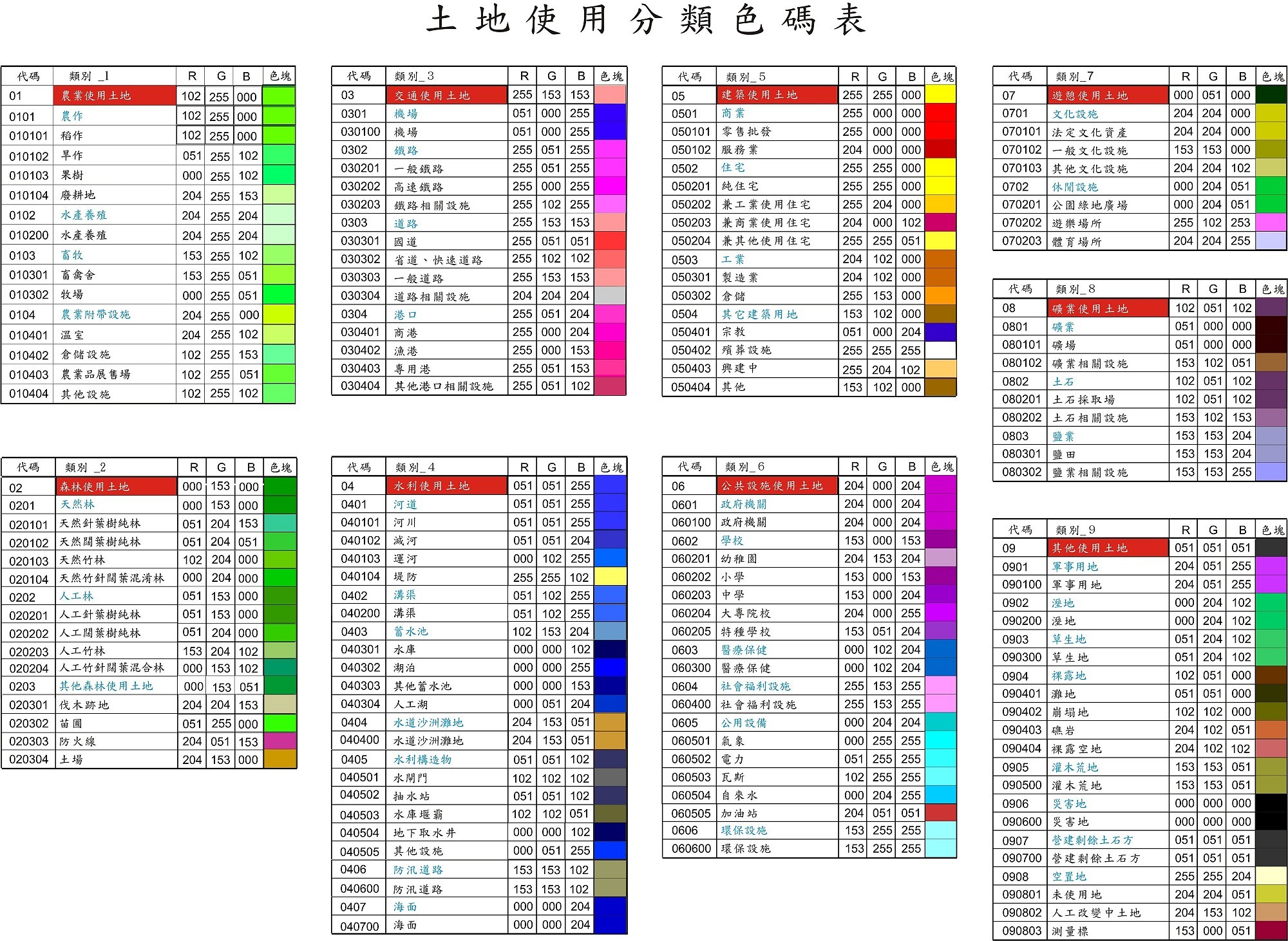
Our web map provides not only the LUI map layer, but also implement the query service that users could right-click at any desired point on the map to get the LUI information. Visit http://lui.nlsc.gov.tw for more information. |
Remark: |
Land Use Zoning Map of Urban Planning [Category:Land Layer] | Date:2021.11.22 |
About Maps: |
The source data is authorized for use by Urban and Rural Development Branch, Construction and Planning Agency, Ministry of the Interior, that creates the urban planning zoning maps for the whole country. The map is shown the zoning information for every urban planning division in Taiwan at a scale of 1:3000. The NLSC has integrated the information along with the zoning data that local government provide, combined them as a layer in our web service. If there is any zoning conflict between our web service and the announcement made by competent authority, the announcement made by competent authority shall prevail for all purposes. Visit http://luz.tcd.gov.tw/ for more information. |
Remark: |
Land Use Zoning Map of Non-urban Land [Category:Land Layer] | Date:2021.11.22 |
About Maps: |
The source data is authorized for use by Urban and Rural Development Branch, Construction and Planning Agency, Ministry of the Interior, that creates the non-urban planning zoning maps for the whole country. The map is shown the zoning information for every non-urban area in Taiwan at a scale of 1:1200, and is generally updated once per year. The NLSC has creates the map under article 11 of the operational direction (http://www.land.moi.gov.tw/law/pda/mainframe.asp?LCID=197&lawname=%BBs%A9w...). The color legend is shown below: ![]() Visit http://luz.tcd.gov.tw/ for more information. |
Remark: |
Land Use Zoning Map of Non-urban Land (I [Category:Land Layer] | Date:2014.09.25 |
About Maps: |
The NLSC creates the other type of Land Use Zoning Map of Non-urban Planning, which is based on the data of land ownership, description, and boundary. The color legend is shown below:![]() |
Remark: |
Land Use Type Map of Non-urban Land [Category:Land Layer] | Date:2016.06.14 |
About Maps: |
The NLSC creates Land Use Type Map of Non-urban Land, which is based on the data of land ownership, description and boundary from the cadastral map, and is followed by the operational direction that the MOI has issued. The color legend is shown below: ![]() |
Remark: |
Cadastral Map (Approximate position) [Category:Land Layer] | Date:2014.06.10 |
About Maps: |
In Taiwan, the cadastral map can be divided into two types of map based on the surveying method: numerical and digitized. The numerical cadastral map is the cadastral resurvey after 1989 using the numeric approach. The numeric approach has adopted several surveying systems, therefor the result stored in different coordinate system, including TWD67, TWD97, and TWD2010. While the digitized cadastral map is the survey results conducted prior to the cadastral resurvey, the NLSC leads a project that digitizing those results of written records and paper maps from 1997 to 2005. The paper map sheets created at different time periods could be at different scale, e.g., 1:500, 1:600, 1:1000, 1:2000, 1:3000, and could be in different coordinate system as well, e.g., the Cadastral Coordinate System, TWD67, TWD97. Given the complexity of circumstance, edge-matching the adjacent map sheets could be diffcult; the map sheets may overlap to the edge of each other. On top of that, there could be some differences between the map the NLSC created and the survey recently done by the local land office. Therefore, this map is to be used for reference purposes only. If you need more specific information about certain area or have question with its land registration, you should contact your local land office or request service such as survey for boundary verification. |
Remark: |
Wildlife sanctuary [Category:Environment Layer] | Date:2014.03.27 |
About Maps: |
Remark: |
Potential debris flow torrent map [Category:Disaster potential Layer] | Date:2021.04.01 |
About Maps: |
The NLSC creates the map using the data that Soil and Water Conservation Bureau (SWCB), Council of Agriculture, published on Debris Flow Disaster Prevention Information website (https://data.coa.gov.tw/Query/ServiceDetail.aspx?id=H83). |
Remark: |
Potential debris flow torrent extends map [Category:Disaster potential Layer] | Date:2021.04.01 |
About Maps: |
The NLSC creates the map using the data that Soil and Water Conservation Bureau (SWCB), Council of Agriculture, published on Debris Flow Disaster Prevention Information website (https://data.coa.gov.tw/Query/ServiceDetail.aspx?id=H84). |
Remark: |
School Boundary Map [Category:Land Layer] | Date:2017.11.02 |
About Maps: |
The NLSC extract all the school data out of Taiwan e-Map, creates as a layer that filled them with colors and patterns by the level of education. The color legend is listed below:![]() |
Remark: |
Tsunami Inundation Potential Maps [Category:Disaster potential Layer] | Date:2015.03.13 |
About Maps: |
The NLSC creates the map using the potentially hazardous areas that the National Science and Technology Center for Disaster Reduction published on http://satis.ncdr.nat.gov.tw/dmap102/102gis_tsunami.aspx The color legend is listed below: ![]() |
Remark: |
Taiwan e-Map (Orthophoto, 2003-2005) [Category:Aerial photographs Layer] | Date:2014.12.10 |
About Maps: |
Taiwan e-Map (Orthophoto, 2003-2005) |
Remark: |
Taiwan e-Map(EN) [Category:Traffic Layer] | Date:2015.01.21 |
About Maps: |
Remark: |
Orthophoto 2017(Kinmen County Government) [Category:] | Date:2019.06.03 |
About Maps: |
Kinmen County Government has authorized their orthophoto to be use as one of the layer in our mapping service since May 2017. |
Remark: |
Orthophoto 2011(Kinmen County Government) [Category:] | Date:2015.09.14 |
About Maps: |
Kinmen County Government has authorized their orthophoto to be use as one of the layer in our mapping service since May 2015. |
Remark: |
Coastal Areas [Category:Environment Layer] | Date:2018.09.10 |
About Maps: |
The NLSC creates the map using the data that the CPA publishes on their website (https://www.cpami.gov.tw/最新消息/業務新訊/10161-海岸地區範圍.html ). |
Remark: |
Geology sensitive areas [Category:Disaster potential Layer] | Date:2021.08.06 |
About Maps: |
The NLSC creates the map using only the geologically sensitive area that recoded using TWD97, which the Central Geological Survey (CGS) of the Ministry of Economic Affairs publishes on This layer contains information about geological relics, groundwater recharge areas, and active faults (landslide and landslip locations are categorized under the other sensitive area layer). Visit |
Remark: |
Agricultural Resource Map (2013) [Category:Agriculture Layer] | Date:2016.03.18 |
About Maps: |
The NLSC creates the map under a mapping agreement with the Council of Agriculture (COA), who provides the agricultural resource vector data collected during 2013. The map covers only Hualien County, Chiayi County, Chiayi City, Tainan City, Kaohsiung City, Pingtung County and Taitung County. |
Remark: |
State-owned land [Category:Land Layer] | Date:2016.09.07 |
About Maps: |
Remark: |
[Category:] | Date:2018.02.12 |
About Maps: |
Taiwan e-Map(new) |
Remark: |
SPOT Image 2018 [Category:] | Date:2019.02.21 |
About Maps: |
Center for Space and Remote Sensing Research, National Central University provides their SPOT Satellite Images captured during 2018. Visit http://data.csrsr.ncu.edu.tw/index_WMTS.php for more information. |
Remark: |
SPOT Image 2017 [Category:] | Date:2018.05.24 |
About Maps: |
Center for Space and Remote Sensing Research, National Central University provides their SPOT Satellite Images captured during 2017. Visit http://data.csrsr.ncu.edu.tw/index_WMTS.php for more information. |
Remark: |
SPOT Image 2016 [Category:] | Date:2018.05.24 |
About Maps: |
Center for Space and Remote Sensing Research, National Central University provides their SPOT Satellite Images captured during 2016. Visit http://data.csrsr.ncu.edu.tw/index_WMTS.php for more information. |
Remark: |
SPOT Image 2015 [Category:] | Date:2016.11.22 |
About Maps: |
Center for Space and Remote Sensing Research, National Central University provides their SPOT Satellite Images captured during 2015. Visit http://data.csrsr.ncu.edu.tw/index_WMTS.php for more information. |
Remark: |
SPOT Image 2014 [Category:] | Date:2016.05.31 |
About Maps: |
Center for Space and Remote Sensing Research, National Central University provides their SPOT Satellite Images captured during 2014. Visit http://data.csrsr.ncu.edu.tw/index_WMTS.php for more information. |
Remark: |
SPOT Image 2013 [Category:] | Date:2016.11.22 |
About Maps: |
Center for Space and Remote Sensing Research, National Central University provides their SPOT Satellite Images captured during 2013. Visit http://data.csrsr.ncu.edu.tw/index_WMTS.php for more information. |
Remark: |
SPOT Image 2012 [Category:] | Date:2016.11.22 |
About Maps: |
Center for Space and Remote Sensing Research, National Central University provides their SPOT Satellite Images captured during 2012. Visit http://data.csrsr.ncu.edu.tw/index_WMTS.php for more information. |
Remark: |
SPOT Image 2011 [Category:] | Date:2016.11.22 |
About Maps: |
Center for Space and Remote Sensing Research, National Central University provides their SPOT Satellite Images captured during 2011. Visit http://data.csrsr.ncu.edu.tw/index_WMTS.php for more information. |
Remark: |
SPOT Image 2010 [Category:] | Date:2016.11.22 |
About Maps: |
Center for Space and Remote Sensing Research, National Central University provides their SPOT Satellite Images captured during 2010. Visit http://data.csrsr.ncu.edu.tw/index_WMTS.php for more information. |
Remark: |
SPOT Image 2009 [Category:] | Date:2016.11.22 |
About Maps: |
Center for Space and Remote Sensing Research, National Central University provides their SPOT Satellite Images captured during 2009. Visit http://data.csrsr.ncu.edu.tw/index_WMTS.php for more information. |
Remark: |
SPOT Image 2008 [Category:] | Date:2016.11.22 |
About Maps: |
Center for Space and Remote Sensing Research, National Central University provides their SPOT Satellite Images captured during 2008. Visit http://data.csrsr.ncu.edu.tw/index_WMTS.php for more information. |
Remark: |
SPOT Image 2007 [Category:] | Date:2016.11.22 |
About Maps: |
Center for Space and Remote Sensing Research, National Central University provides their SPOT Satellite Images captured during 2007. Visit http://data.csrsr.ncu.edu.tw/index_WMTS.php for more information. |
Remark: |
SPOT Image 2006 [Category:] | Date:2016.11.22 |
About Maps: |
Center for Space and Remote Sensing Research, National Central University provides their SPOT Satellite Images captured during 2006. Visit http://data.csrsr.ncu.edu.tw/index_WMTS.php for more information. |
Remark: |
SPOT Image 2005 [Category:] | Date:2016.11.22 |
About Maps: |
Center for Space and Remote Sensing Research, National Central University provides their SPOT Satellite Images captured during 2005. Visit http://data.csrsr.ncu.edu.tw/index_WMTS.php for more information. |
Remark: |
SPOT Image 2004 [Category:] | Date:2016.11.22 |
About Maps: |
Center for Space and Remote Sensing Research, National Central University provides their SPOT Satellite Images captured during 2004. Visit http://data.csrsr.ncu.edu.tw/index_WMTS.php for more information. |
Remark: |
[Category:Land Layer] | Date:2017.11.28 |
About Maps: |
Remark: |
[Category:Land Layer] | Date:2017.10.25 |
About Maps: |
Remark: |
Aspect Map [Category:] | Date:2017.09.14 |
About Maps: |
aspect map |
Remark: |
MOI_SLOPEP_GT30(2003-2005) [Category:] | Date:2019.06.10 |
About Maps: |
MOI_SLOPEP_GT30(2003-2005) |
Remark: |
MOI_SLOPEP_LV7(2003-2005) [Category:] | Date:2018.01.22 |
About Maps: |
MOI_SLOPEP_LV7(2003-2005) |
Remark: |
Contour Map(2003-2005) [Category:] | Date:2017.09.14 |
About Maps: |
contour map(2003-2005) |
Remark: |
Contour Map(2010-2015) [Category:] | Date:2018.11.21 |
About Maps: |
Contour Map(2010-2015) |
Remark: |
Render Map [Category:] | Date:2017.09.14 |
About Maps: |
Remark: |
Shade Map [Category:] | Date:2017.09.14 |
About Maps: |
Shade Map |
Remark: |
flooded_24H200mm [Category:Disaster potential Layer] | Date:2020.05.28 |
About Maps: |
![]() |
Remark: |
flooded_24H350mm [Category:Disaster potential Layer] | Date:2020.05.28 |
About Maps: |
![]() |
Remark: |
flooded_24H500mm [Category:Disaster potential Layer] | Date:2020.05.28 |
About Maps: |
![]() |
Remark: |
flooded_24H650mm [Category:Disaster potential Layer] | Date:2020.05.28 |
About Maps: |
![]() |
Remark: |
flooded_12H200mm [Category:Disaster potential Layer] | Date:2020.05.28 |
About Maps: |
![]() |
Remark: |
flooded_12H300mm [Category:Disaster potential Layer] | Date:2020.05.28 |
About Maps: |
![]() |
Remark: |
flooded_12H400mm [Category:Disaster potential Layer] | Date:2020.05.28 |
About Maps: |
![]() |
Remark: |
flooded_6H150mm [Category:Disaster potential Layer] | Date:2020.05.28 |
About Maps: |
![]() |
Remark: |
flooded_6H250mm [Category:Disaster potential Layer] | Date:2020.05.28 |
About Maps: |
![]() |
Remark: |
flooded_6H350mm [Category:Disaster potential Layer] | Date:2020.05.28 |
About Maps: |
![]() |
Remark: |
Landsat8 [Category:Satellite imagery Layer] | Date:2017.09.21 |
About Maps: |
Landsat8Landsat 8 WMTS Service.「Open Access Satellite Image Service (OASIS) of Taiwan」) http://gis.sinica.edu.tw/landsat8/wmts |
Remark: |
fireplug [Category:Disaster potential Layer] | Date:2018.01.26 |
About Maps: |
fire hydrant |
Remark: |
LUIMAP class 01 [Category:Land Use Survey Layer] | Date:2018.05.05 |
About Maps: |
Remark: |
LUIMAP class 02 [Category:Land Use Survey Layer] | Date:2018.05.05 |
About Maps: |
Remark: |
LUIMAP class 03 [Category:Land Use Survey Layer] | Date:2018.05.05 |
About Maps: |
Remark: |
LUIMAP class 04 [Category:Land Use Survey Layer] | Date:2018.05.05 |
About Maps: |
Remark: |
LUIMAP class 05 [Category:Land Use Survey Layer] | Date:2018.05.05 |
About Maps: |
Remark: |
LUIMAP class 06 [Category:Land Use Survey Layer] | Date:2018.05.05 |
About Maps: |
Remark: |
LUIMAP class 07 [Category:Land Use Survey Layer] | Date:2018.05.05 |
About Maps: |
Remark: |
LUIMAP class 08 [Category:Land Use Survey Layer] | Date:2018.05.05 |
About Maps: |
Remark: |
LUIMAP class 09 [Category:Land Use Survey Layer] | Date:2018.05.05 |
About Maps: |
Remark: |
Land Use Investigation (LUI) Map [Category:Land Use Survey Layer] | Date:2018.05.09 |
About Maps: |
Remark: |
Intertidal Zone [Category:Environment Layer] | Date:2018.09.10 |
About Maps: |
The NLSC creates the map using the data that the CPA publishes on their website (https://www.cpami.gov.tw/最新消息/業務新訊/10161-海岸地區範圍.html ). |
Remark: |
[Category:] | Date:2018.12.13 |
About Maps: |
Remark: |
MOI_SLOPEP_GT30(2010-2015) [Category:] | Date:2019.06.04 |
About Maps: |
MOI_SLOPEP_GT30(2010-2015) |
Remark: |
MOI_SLOPEP_LV7(2010-2015) [Category:] | Date:2018.11.20 |
About Maps: |
MOI_SLOPEP_LV7(2010-2015) |
Remark: |
SPOT Image 2018 (penghu) [Category:] | Date:2019.05.22 |
About Maps: |
Center for Space and Remote Sensing Research, National Central University provides their SPOT Satellite Images captured during 2018. Visit http://data.csrsr.ncu.edu.tw/index_WMTS.php for more information. |
Remark: |
SPOT Image 2017 (penghu) [Category:] | Date:2019.05.22 |
About Maps: |
Center for Space and Remote Sensing Research, National Central University provides their SPOT Satellite Images captured during 2017. Visit http://data.csrsr.ncu.edu.tw/index_WMTS.php for more information. |
Remark: |
SPOT Image 2016 (penghu) [Category:] | Date:2019.05.22 |
About Maps: |
Center for Space and Remote Sensing Research, National Central University provides their SPOT Satellite Images captured during 2016. Visit http://data.csrsr.ncu.edu.tw/index_WMTS.php for more information. |
Remark: |
SPOT Image 2015 (penghu) [Category:] | Date:2019.05.22 |
About Maps: |
Center for Space and Remote Sensing Research, National Central University provides their SPOT Satellite Images captured during 2015. Visit http://data.csrsr.ncu.edu.tw/index_WMTS.php for more information. |
Remark: |
SPOT Image 2014 (penghu) [Category:] | Date:2019.05.22 |
About Maps: |
Center for Space and Remote Sensing Research, National Central University provides their SPOT Satellite Images captured during 2014. Visit http://data.csrsr.ncu.edu.tw/index_WMTS.php for more information. |
Remark: |
SPOT Image 2013 (penghu) [Category:] | Date:2019.05.22 |
About Maps: |
Center for Space and Remote Sensing Research, National Central University provides their SPOT Satellite Images captured during 2013. Visit http://data.csrsr.ncu.edu.tw/index_WMTS.php for more information. |
Remark: |
SPOT Image 2012 (penghu) [Category:] | Date:2019.05.22 |
About Maps: |
Center for Space and Remote Sensing Research, National Central University provides their SPOT Satellite Images captured during 2012. Visit http://data.csrsr.ncu.edu.tw/index_WMTS.php for more information. |
Remark: |
SPOT Image 2011 (penghu) [Category:] | Date:2019.05.22 |
About Maps: |
Center for Space and Remote Sensing Research, National Central University provides their SPOT Satellite Images captured during 2011. Visit http://data.csrsr.ncu.edu.tw/index_WMTS.php for more information. |
Remark: |
SPOT Image 2010 (penghu) [Category:] | Date:2019.05.22 |
About Maps: |
Center for Space and Remote Sensing Research, National Central University provides their SPOT Satellite Images captured during 2010. Visit http://data.csrsr.ncu.edu.tw/index_WMTS.php for more information. |
Remark: |
SPOT Image 2009 (penghu) [Category:] | Date:2019.05.22 |
About Maps: |
Center for Space and Remote Sensing Research, National Central University provides their SPOT Satellite Images captured during 2009. Visit http://data.csrsr.ncu.edu.tw/index_WMTS.php for more information. |
Remark: |
SPOT Image 2008 (penghu) [Category:] | Date:2019.05.22 |
About Maps: |
Center for Space and Remote Sensing Research, National Central University provides their SPOT Satellite Images captured during 2008. Visit http://data.csrsr.ncu.edu.tw/index_WMTS.php for more information. |
Remark: |
SPOT Image 2007 (penghu) [Category:] | Date:2019.05.22 |
About Maps: |
Center for Space and Remote Sensing Research, National Central University provides their SPOT Satellite Images captured during 2007. Visit http://data.csrsr.ncu.edu.tw/index_WMTS.php for more information. |
Remark: |
SPOT Image 2006 (penghu) [Category:] | Date:2019.05.22 |
About Maps: |
Center for Space and Remote Sensing Research, National Central University provides their SPOT Satellite Images captured during 2006. Visit http://data.csrsr.ncu.edu.tw/index_WMTS.php for more information. |
Remark: |
SPOT Image 2005 (penghu) [Category:] | Date:2019.05.22 |
About Maps: |
Center for Space and Remote Sensing Research, National Central University provides their SPOT Satellite Images captured during 2005. Visit http://data.csrsr.ncu.edu.tw/index_WMTS.php for more information. |
Remark: |
SPOT Image 2004 (penghu) [Category:] | Date:2019.05.22 |
About Maps: |
Center for Space and Remote Sensing Research, National Central University provides their SPOT Satellite Images captured during 2004. Visit http://data.csrsr.ncu.edu.tw/index_WMTS.php for more information. |
Remark: |
Date:2020.02.12 |
About Maps: |
Remark: |
SPOT Image 2019 [Category:] | Date:2020.04.06 |
About Maps: |
Center for Space and Remote Sensing Research, National Central University provides their SPOT Satellite Images captured during 2019. Visit http://data.csrsr.ncu.edu.tw/index_WMTS.php for more information. |
Remark: |
SPOT Image 2019 (penghu) [Category:] | Date:2020.04.06 |
About Maps: |
Center for Space and Remote Sensing Research, National Central University provides their SPOT Satellite Images captured during 2019. Visit http://data.csrsr.ncu.edu.tw/index_WMTS.php for more information. |
Remark: |
[Category:Basic Picture Layer] | Date:2022.05.16 |
About Maps: |
Remark: |
[Category:Basic Picture Layer] | Date:2022.05.16 |
About Maps: |
Remark: |
[Category:Basic Picture Layer] | Date:2022.05.16 |
About Maps: |
Remark: |
LiDAR2020 [Category:Airborne Lidar Layer] | Date:2021.03.25 |
About Maps: |
National Land Surveying and Mapping Center (NLSC) had used airborne LiDAR to scan parts area, and additionally, produced 527 frames of digital orthophoto-images. |
Remark: |
LiDAR2021 [Category:Airborne Lidar Layer] | Date:2022.08.15 |
About Maps: |
National Land Surveying and Mapping Center (NLSC) had used airborne LiDAR to scan parts area, and additionally, produced 660 frames of digital orthophoto-images. |
Remark: |
LiDAR2019 [Category:Airborne Lidar Layer] | Date:2020.04.21 |
About Maps: |
National Land Surveying and Mapping Center (NLSC) had used airborne LiDAR to scan parts area of 6 counties and cities of the country, and additionally, produced 529 frames of digital orthophoto-images. |
Remark: |
SPOT Image 2020 (penghu) [Category:] | Date:2021.06.29 |
About Maps: |
Center for Space and Remote Sensing Research, National Central University provides their SPOT Satellite Images captured during 2020. Visit http://data.csrsr.ncu.edu.tw/index_WMTS.php for more information. |
Remark: |
SPOT Image 2020 [Category:] | Date:2021.06.29 |
About Maps: |
Center for Space and Remote Sensing Research, National Central University provides their SPOT Satellite Images captured during 2020. Visit http://data.csrsr.ncu.edu.tw/index_WMTS.php for more information. |
Remark: |
[Category:Land Layer] | Date:2022.10.04 |
About Maps: |
Remark: |
[Category:Disaster potential Layer] | Date:2022.10.14 |
About Maps: |
Remark: |
[Category:Disaster potential Layer] | Date:2022.10.14 |
About Maps: |
Remark: |
[Category:Disaster potential Layer] | Date:2022.12.26 |
About Maps: |
Remark: |
temp [Category:] | Date:2022.11.17 |
About Maps: |
Remark: |
Aerial Imagery (Taipei City) [Category:] | Date:2022.11.17 |
About Maps: |
Department of Urban Development, Taipei City Government provides their aerial photography captured during . The imagery is also provided as WMTS layer on their mapping system at http://www.historygis.udd.taipei.gov.tw/urban/map/ |
Remark: |
[Category:Environment Layer] | Date:2022.12.16 |
About Maps: |
Remark: |
[Category:Disaster potential Layer] | Date:2022.12.28 |
About Maps: |
Remark: |
LiDAR2022 [Category:Airborne Lidar Layer] | Date:2023.06.19 |
About Maps: |
National Land Surveying and Mapping Center (NLSC) had used airborne LiDAR to scan parts area, and additionally, produced 850 frames of digital orthophoto-images. |
Remark: |
[Category:] | Date:2023.10.30 |
About Maps: |
Remark: |
test [Category:] | Date:2024.03.14 |
About Maps: |
Remark: |
[Category:] | Date:2024.03.15 |
About Maps: |
Remark: |
[Category:] | Date:2024.03.15 |
About Maps: |
Remark: |
[Category:] | Date:2024.03.15 |
About Maps: |
Remark: |
[Category:] | Date:2024.03.15 |
About Maps: |
Remark: |
[Category:] | Date:2024.03.15 |
About Maps: |
Remark: |
[Category:] | Date:2024.03.15 |
About Maps: |
Remark: |
[Category:] | Date:2024.03.15 |
About Maps: |
Remark: |
[Category:] | Date:2024.03.15 |
About Maps: |
Remark: |
[Category:] | Date:2024.03.15 |
About Maps: |
Remark: |
[Category:] | Date:2024.03.15 |
About Maps: |
Remark: |
[Category:Environment Layer] | Date:2024.04.30 |
About Maps: |
Remark: |
[Category:Environment Layer] | Date:2024.04.30 |
About Maps: |
Remark: |
[Category:] | Date:2024.06.06 |
About Maps: |
Remark: |
[Category:] | Date:2024.06.06 |
About Maps: |
Remark: |
[Category:] | Date:2024.06.21 |
About Maps: |
Remark: |
[Category:] | Date:2024.06.21 |
About Maps: |
Remark: |
[Category:] | Date:2024.06.21 |
About Maps: |
Remark: |
[Category:] | Date:2024.06.21 |
About Maps: |
Remark: |
[Category:] | Date:2024.06.21 |
About Maps: |
Remark: |
[Category:] | Date:2024.06.21 |
About Maps: |
Remark: |
[Category:] | Date:2024.06.21 |
About Maps: |
Remark: |
[Category:] | Date:2024.06.21 |
About Maps: |
Remark: |
[Category:] | Date:2024.06.21 |
About Maps: |
Remark: |
[Category:] | Date:2024.06.21 |
About Maps: |
Remark: |
[Category:1/5000 Topographic Layer] | Date:2024.09.13 |
About Maps: |
Remark: |
[Category:Basic Picture Layer] | Date:2024.09.13 |
About Maps: |
Remark: |
[Category:Land Use Survey Layer] | Date:2024.09.16 |
About Maps: |
Remark: |
LiDAR2023 [Category:Airborne Lidar Layer] | Date:2024.11.16 |
About Maps: |
Remark: |
LiDAR2024 [Category:Airborne Lidar Layer] | Date:2024.11.18 |
About Maps: |
Remark: |
[Category:EC Topographic Layer] | Date:2024.11.27 |
About Maps: |
Remark: |
[Category:EC Topographic Layer] | Date:2024.11.27 |
About Maps: |
Remark: |
[Category:EC Topographic Layer] | Date:2024.11.27 |
About Maps: |
Remark: |
[Category:EC Topographic Layer] | Date:2024.11.27 |
About Maps: |
Remark: |
[Category:EC Topographic Layer] | Date:2024.11.27 |
About Maps: |
Remark: |
Land Use Investigation (LUI) M [Category:Land Use Survey Layer] | Date:2024.12.11 |
About Maps: |
Land Use Investigation (LUI) Map 2024update |
Remark: |
Village202408 [Category:] | Date:2024.12.13 |
About Maps: |
Remark: |
Village202410 [Category:] | Date:2024.12.13 |
About Maps: |
Remark: |
Village202411 [Category:] | Date:2024.12.13 |
About Maps: |
Remark: |
TOWN202410 [Category:] | Date:2024.12.13 |
About Maps: |
Remark: |
SPOT2022_PH [Category:] | Date:2025.02.19 |
About Maps: |
Remark: |
[Category:] | Date:2025.02.19 |
About Maps: |
Remark: |
[Category:] | Date:2025.02.19 |
About Maps: |
Remark: |
[Category:] | Date:2025.02.19 |
About Maps: |
Remark: |
[Category:] | Date:2025.02.19 |
About Maps: |
Remark: |
[Category:] | Date:2025.02.19 |
About Maps: |
Remark: |
[Category:]
![]() |
Date:2025.03.29 |
About Maps: |
Remark: |
[Category:]
![]() |
Date:2025.03.29 |
About Maps: |
Remark: |
[Category:]
![]() |
Date:2025.03.30 |
About Maps: |
Remark: |
[Category:]
![]() |
Date:2025.03.30 |
About Maps: |
Remark: |
[Category:]
![]() |
Date:2025.03.30 |
About Maps: |
Remark: |
[Category:]
![]() |
Date:2025.03.30 |
About Maps: |
Remark: |
[Category:]
![]() |
Date:2025.03.30 |
About Maps: |
Remark: |
[Category:]
![]() |
Date:2025.03.30 |
About Maps: |
Remark: |
[Category:]
![]() |
Date:2025.03.30 |
About Maps: |
Remark: |
[Category:]
![]() |
Date:2025.03.30 |
About Maps: |
Remark: |
[Category:]
![]() |
Date:2025.03.30 |
About Maps: |
Remark: |
[Category:]
![]() |
Date:2025.03.30 |
About Maps: |
Remark: |
[Category:]
![]() |
Date:2025.03.30 |
About Maps: |
Remark: |
[Category:]
![]() |
Date:2025.03.30 |
About Maps: |
Remark: |
[Category:]
![]() |
Date:2025.03.30 |
About Maps: |
Remark: |
[Category:]
![]() |
Date:2025.03.30 |
About Maps: |
Remark: |
[Category:]
![]() |
Date:2025.03.30 |
About Maps: |
Remark: |
[Category:]
![]() |
Date:2025.03.30 |
About Maps: |
Remark: |
[Category:]
![]() |
Date:2025.03.30 |
About Maps: |
Remark: |
[Category:]
![]() |
Date:2025.03.30 |
About Maps: |
Remark: |
[Category:]
![]() |
Date:2025.03.30 |
About Maps: |
Remark: |
[Category:]
![]() |
Date:2025.03.30 |
About Maps: |
Remark: |
[Category:]
![]() |
Date:2025.03.30 |
About Maps: |
Remark: |
[Category:]
![]() |
Date:2025.03.30 |
About Maps: |
Remark: |
[Category:]
![]() |
Date:2025.03.30 |
About Maps: |
Remark: |
[Category:]
![]() |
Date:2025.03.30 |
About Maps: |
Remark: |
[Category:]
![]() |
Date:2025.03.30 |
About Maps: |
Remark: |
[Category:]
![]() |
Date:2025.03.30 |
About Maps: |
Remark: |
[Category:]
![]() |
Date:2025.03.30 |
About Maps: |
Remark: |
[Category:]
![]() |
Date:2025.03.30 |
About Maps: |
Remark: |
[Category:]
![]() |
Date:2025.03.30 |
About Maps: |
Remark: |
[Category:]
![]() |
Date:2025.03.30 |
About Maps: |
Remark: |
[Category:]
![]() |
Date:2025.03.30 |
About Maps: |
Remark: |
[Category:]
![]() |
Date:2025.03.30 |
About Maps: |
Remark: |
[Category:]
![]() |
Date:2025.03.30 |
About Maps: |
Remark: |
[Category:]
![]() |
Date:2025.03.30 |
About Maps: |
Remark: |
[Category:]
![]() |
Date:2025.03.30 |
About Maps: |
Remark: |
[Category:]
![]() |
Date:2025.03.30 |
About Maps: |
Remark: |
[Category:]
![]() |
Date:2025.03.30 |
About Maps: |
Remark: |
[Category:]
![]() |
Date:2025.03.30 |
About Maps: |
Remark: |
[Category:]
![]() |
Date:2025.03.30 |
About Maps: |
Remark: |
[Category:]
![]() |
Date:2025.03.30 |
About Maps: |
Remark: |
[Category:]
![]() |
Date:2025.03.30 |
About Maps: |
Remark: |
[Category:]
![]() |
Date:2025.03.30 |
About Maps: |
Remark: |
[Category:]
![]() |
Date:2025.03.30 |
About Maps: |
Remark: |
[Category:]
![]() |
Date:2025.03.30 |
About Maps: |
Remark: |
[Category:]
![]() |
Date:2025.03.30 |
About Maps: |
Remark: |
[Category:]
![]() |
Date:2025.03.30 |
About Maps: |
Remark: |
[Category:]
![]() |
Date:2025.03.30 |
About Maps: |
Remark: |
[Category:]
![]() |
Date:2025.03.30 |
About Maps: |
Remark: |
[Category:]
![]() |
Date:2025.03.30 |
About Maps: |
Remark: |
[Category:]
![]() |
Date:2025.03.30 |
About Maps: |
Remark: |
[Category:]
![]() |
Date:2025.03.30 |
About Maps: |
Remark: |
[Category:]
![]() |
Date:2025.03.30 |
About Maps: |
Remark: |
[Category:]
![]() |
Date:2025.03.30 |
About Maps: |
Remark: |
[Category:]
![]() |
Date:2025.03.30 |
About Maps: |
Remark: |
[Category:]
![]() |
Date:2025.03.30 |
About Maps: |
Remark: |
[Category:]
![]() |
Date:2025.03.30 |
About Maps: |
Remark: |
[Category:]
![]() |
Date:2025.03.30 |
About Maps: |
Remark: |
[Category:]
![]() |
Date:2025.03.30 |
About Maps: |
Remark: |
[Category:]
![]() |
Date:2025.03.30 |
About Maps: |
Remark: |
[Category:]
![]() |
Date:2025.03.30 |
About Maps: |
Remark: |
[Category:]
![]() |
Date:2025.03.30 |
About Maps: |
Remark: |
[Category:]
![]() |
Date:2025.03.30 |
About Maps: |
Remark: |
[Category:]
![]() |
Date:2025.03.30 |
About Maps: |
Remark: |
[Category:]
![]() |
Date:2025.03.30 |
About Maps: |
Remark: |
[Category:]
![]() |
Date:2025.03.30 |
About Maps: |
Remark: |
[Category:]
![]() |
Date:2025.03.30 |
About Maps: |
Remark: |
[Category:]
![]() |
Date:2025.03.30 |
About Maps: |
Remark: |
[Category:]
![]() |
Date:2025.03.30 |
About Maps: |
Remark: |
[Category:]
![]() |
Date:2025.03.30 |
About Maps: |
Remark: |
[Category:]
![]() |
Date:2025.03.30 |
About Maps: |
Remark: |
[Category:]
![]() |
Date:2025.03.30 |
About Maps: |
Remark: |
[Category:]
![]() |
Date:2025.03.30 |
About Maps: |
Remark: |
[Category:]
![]() |
Date:2025.03.30 |
About Maps: |
Remark: |
[Category:]
![]() |
Date:2025.03.30 |
About Maps: |
Remark: |
[Category:]
![]() |
Date:2025.03.30 |
About Maps: |
Remark: |
[Category:]
![]() |
Date:2025.03.30 |
About Maps: |
Remark: |
[Category:]
![]() |
Date:2025.03.30 |
About Maps: |
Remark: |
[Category:]
![]() |
Date:2025.03.30 |
About Maps: |
Remark: |
[Category:Land Layer]
![]() |
Date:2025.04.15 |
About Maps: |
Remark: |
[Category:1/5000 Topographic Layer]
![]() |
Date:2025.04.15 |
About Maps: |
Remark: |
[Category:Basic Picture Layer]
![]() |
Date:2025.04.15 |
About Maps: |
Remark: |